Add Row
Add Element
cropper
update
Drone Central Station
update
Add Element
  • Home
  • Categories
    • Drone Tech
    • Drone Applications
    • Drone Racing
    • Accessories
    • Real Estate
    • Military
    • Disaster
    • Drone Footage
    • Product Reviews
    • Business Profiles
August 05.2025
3 Minutes Read

Quick and Easy FAA Airspace Authorization Using LAANC

FAA Airspace Authorization Using LAANC: Smartphone map and drone.

Understanding Airspace Authorization: What Every Drone Pilot Needs to Know

As drone technology gains traction among hobbyists and professionals alike, understanding airspace regulations is more crucial than ever. In controlled airspace—those near airports and busy air traffic zones—pilots must secure authorization before flying. This precaution not only ensures safety but also keeps pilots compliant with the FAA's regulations.

In 'How To Get FAA Airspace Authorization Using LAANC', the discussion dives into the vital process of securing drone flight permissions, exploring key insights that sparked deeper analysis on our end.

Why Airspace Classification Matters

The airspace is divided into classifications (A, B, C, D, and E), where Classes B, C, D, and E are controlled airspace. These areas typically host more manned aircraft, which poses safety risks for drone operations. Thus, if you're flying in these zones, you are required to obtain FAA authorization.

Getting Authorization Made Easy with LAANC

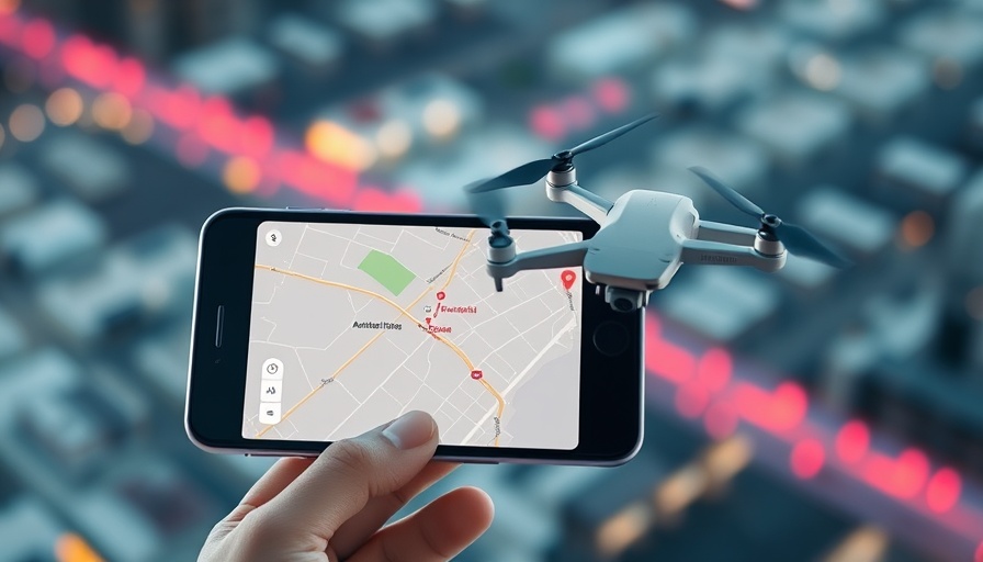
Fortunately, securing this authorization isn’t an uphill battle. Through the use of the Low Altitude Authorization and Notification Capability (LAANC), pilots can easily request permission to operate in controlled airspace using apps like Autopilot and Aloft. The entire process can take as little as 30 seconds, making it both speedy and efficient.

A Step-by-Step Guide to Using the Apps

If you’re eager to get started, here’s a simplified breakdown:

  • Open Your Chosen App: Both Autopilot and Aloft provide user-friendly interfaces that enable you to locate your intended flight area.
  • Select Airspace: Tap the area you wish to fly in. The app will provide you with information on altitude restrictions and any alerts, such as temporary flight restrictions.
  • Specify Flight Details: Input your desired altitude (up to 400 ft in many cases), the duration of your flight, and the intended mission date.
  • Submit Your Request: After providing the necessary details, submit your request and wait for the authorization. You’ll receive a confirmation shortly after.

Exciting Benefits of Using LAANC

This system offers more than just an easy application process. LAANC features several benefits:

  • Instant Approval: Unlike traditional routes that may take longer, LAANC can deliver quick authorizations, allowing for more spontaneous drone flights.
  • Accessibility for All Pilots: Both recreational and commercial drone pilots can benefit from LAANC, though commercial users may access additional features.
  • Advance Requests: If you're planning a shoot or commercial job, you can submit requests up to 90 days in advance, adding flexibility to your planning.

Future Trends in Drone Piloting

As drone technology evolves, the regulatory landscape is expected to adapt accordingly. Innovations may lead to more autonomous systems for airspace management, potentially paving the way for more integrated drone operations within controlled airspace. Understanding current systems like LAANC can place you ahead of these trends and prepare you for the future of drone flying.

Final Thoughts: Equip Yourself with Knowledge

In conclusion, whether you're a recreational flyer or a professional pilot, obtaining airspace authorization is a simple yet critical step in ensuring you operate within regulations. Tools like LAANC offer quick, straightforward solutions to safeguarding your flights. If you're ready to take to the skies, dive into these apps and empower your flying experience!

If you found this article helpful, take a moment to explore drone flight apps further and integrate them into your preflight checklist. Understanding the airspace around you not only enhances your flying safety but elevates your drone piloting skills.

Drone Tech

4 Views

0 Comments

Write A Comment

*
*
Related Posts All Posts
09.04.2025

Boosting UAV Navigation Resilience: The Future of GNSS Technology Explained

Update The Evolution of GNSS Resilience in Autonomous Navigation As the demand for reliable autonomous navigation systems grows, particularly in Unmanned Aerial Systems (UAS), the collaboration between UAV Navigation–Grupo Oesía and Septentrio marks a pivotal development in enhancing Global Navigation Satellite System (GNSS) resilience. With the integration of high-precision Real-Time Kinematic (RTK) capabilities and advanced anti-jamming and anti-spoofing technologies, navigational accuracy and dependability are set to receive a significant boost. Understanding Anti-Spoofing and Anti-Jamming Technologies Anti-spoofing protects GNSS users from false signals designed to mislead navigational systems, while anti-jamming technology works to ensure consistent positioning despite interference attempts. The adoption of the Galileo OSNMA (Open Service Navigation Message Authentication) service, combined with Septentrio's specialized algorithms, creates a robust foundation for UAS applications. This is particularly crucial in military and emergency response settings where reliability and precision are non-negotiable. Enhancing Interoperability for Superior Navigation The seamless interoperability between UAV Navigation's and Septentrio's technologies represents a considerable advancement. This cooperation allows the UAV Navigation-Grupo Oesía's Guidance, Navigation, and Control (GNC) systems to automatically recognize and prioritize data from Septentrio's OSNMA-enabled receivers, enhancing overall navigational performance. According to Miguel Ángel de Frutos, CTO at UAV Navigation, achieving interoperability not only enhances resilience but also optimizes navigation in contested environments. The Importance of Resilience in Challenging Environments As operational environments for drones become increasingly complex, ensuring resilient and accurate navigation capabilities is vital. The technology behind anti-jamming and anti-spoofing must be tested against real-world scenarios, something that both partnering companies acknowledge. Gustavo López from Septentrio emphasizes the significance of developing receivers that assure successful missions in both civilian and defense applications, highlighting the urgent need for reliable positioning solutions. Future Insights: Where Autonomous Navigation is Heading The strides made in GNSS technology and its integration with UAS platforms indicate potential trends for future developments in autonomous navigation. As the UAS market evolves, the demand for enhanced security and resilience will only grow, urging industry leaders like UAV Navigation–Grupo Oesía and Septentrio to innovate further. This could include expanding capabilities into autonomous deliveries, search-and-rescue operations, or even autonomous surveillance, where GNSS resilience will be paramount. Overall, the collaboration between UAV Navigation and Septentrio not only positions them as leaders in the field but also sets a new standard for GNSS resilience in autonomous navigation. It exemplifies the innovative spirit that drives the UAS industry and reflects a commitment to developing technologies that meet the stringent demands of modern aerial operations.

09.04.2025

Is the National Airspace Ready for Advanced Air Mobility? Insights from Experts

Update Understanding Advanced Air Mobility: Is Our Airspace Prepared? The recent Commercial UAV Expo held in Las Vegas provided an insightful platform for discussions about Advanced Air Mobility (AAM) and its integration into the National Airspace System (NAS). Experts gathered to evaluate the current state of the airspace and how stakeholders can cooperate as drone operations expand. The State of Our Airspace: Current Infrastructure and Challenges During a panel discussion, moderator Toni Drummond highlighted the question on everyone’s mind: Is the NAS really ready for AAM? Nick Flom, UAS Account Director at Thales USA, confidently asserted that the groundwork for incorporating AAM is already laid in the U.S. He stated, "We already have supporting airports in communities; you don’t necessarily have to fly into the huge national airports." This sentiment reflects a growing recognition of the existing infrastructure's potential to manage both legacy and modern aircraft, facilitating a smoother transition to AAM. However, as Trevor Woods from the Northern Plains UAS Test Site pointed out, the advent of AAM brings its unique challenges. "It’s not just a new airframe, it’s new electronics – and we’re separating the pilot in the cockpit from the operator who may be on the ground," he explained. This operational shift requires a thorough re-examination of current safety protocols and data handling. The Balancing Act of Risk Management Michelle Duquette, Founder and CEO of 3 MAD Air Consulting, framed the integration of AAM within the context of risk management. She emphasized, "It’s all about risk. Risk to the NAS, risk to those maintaining the airspace infrastructure, and we don’t yet have the standards and framework to evaluate risk for AAM and new aircraft." Her concerns raise essential questions about how regulatory bodies will define and mitigate risks associated with this transformative technology. Looking Ahead: The Path to Autonomy in Drone Operations The conversation also turned to the FAA’s Notice of Proposed Rulemaking concerning operations beyond visual line of sight (BVLOS). As Duquette shared, a phased approach seems sensible: "We’re starting with technology as it exists now. We’ll get comfortable with that… electric aviation will transition to autonomy, but we’re not there yet.” Flom reassured attendees that fears of overcrowded skies have not materialized, stating, "Part 107 didn’t ‘darken the skies.’ There aren’t that many drones currently.” This optimistic outlook suggests the potential for a well-regulated, expanded airspace in the near future. Building Collaborative Ecosystems Beyond State Lines One pivotal theme was the need for collaboration across various stakeholders. Drummond noted the aviation industry's legacy of cooperation, questioning how this can continue amid potential competition. Woods praised North Dakota's early recognition of opportunities within AAM, stating, "We want the state to be successful; we want all of the industry to be successful." Flom echoed this sentiment, emphasizing that in aviation, state borders should be irrelevant, calling for a unified approach across jurisdictions. The Critical Issue of Funding Perhaps one of the most pressing concerns discussed was the challenge of funding. Panelists unanimously agreed that securing investment for infrastructure and regulatory development remains one of the largest gaps hindering AAM deployment. As the industry inches closer to reality, diverse funding streams will be essential to foster innovation and support the necessary advancements. In conclusion, as Advanced Air Mobility progresses, it is evident that the National Airspace System must adapt through collaboration, risk management, and sufficient funding. By fostering a culture of cooperation and addressing funding gaps, the future of aerial mobility could be both innovative and safe. If you're intrigued by the potential of drones and AAM, stay updated as developments continue to unfold in this exciting industry!

09.04.2025

Discover How BOLO Drone AI Revolutionizes Proactive Surveillance Capabilities

Update The Future of Drone Surveillance: A New Era of AI IntegrationThe BOLO drone AI from Centinus has been unveiled at the Commercial UAV Expo, a technology poised to revolutionize the way agencies utilize drone technology for public safety and security operations. By incorporating sophisticated artificial intelligence and automation features, the BOLO drone transitions from a passive recorder to a proactive investigative tool, creating a significant leap in situational awareness capabilities.How BOLO Reimagines Object DetectionThe defining feature of BOLO lies in its capacity to interpret natural language requests and execute specific searches. Users can define targets simply by saying or typing descriptions like "white SUV" or "man wearing a red hat." This interactive capability is made possible through the fusion of advanced computer vision techniques and large language modeling. As the drone navigates, its onboard AI combs through live video streams in real time, instantly alerting operators to identified matches while tracking location data. This level of responsiveness redefines operational efficiency and is a game-changer for law enforcement and emergency services.Instant Identification with Zoom to ID FeatureFollowing the identification of a target, operators can utilize the unique Zoom to ID feature to receive a closer evaluation. This functionality highlights subjects in the footage and provides high-resolution images, greatly enhancing the investigation process. For more detailed assessment, the drone also automatically zeroes in on license plates, employing Optical Character Recognition (OCR) to expedite identification, crucial for law enforcement and emergency response.A Unified Approach to Surveillance with Single Pane of GlassAdditionally, Centinus introduces the Single Pane of Glass interface, where users can monitor and analyze multiple drone feeds simultaneously through a single screen. This integration not only enhances the situational awareness across various domains but also allows operators to direct their attention where needed most. By combining AI across diverse sources, this platform showcases an evolution in aerial surveillance coverage, extending its relevance into multiple sectors beyond just public safety.Demonstrating Innovation and CapabilityAt the ongoing Commercial UAV Expo, Centinus is showcasing live demonstrations of the BOLO AI technology, providing attendees with a firsthand look at its operational prowess. Engaging in the Expo’s Pitch the Press program further emphasizes Centinus’ commitment to pioneering breakthroughs within AI-powered drone surveillance. This recognition underscores the societal impact of such innovations in enhancing security protocols and public safety strategies.The Bigger Picture: Implications for Public SafetyJonathan Duff, CEO of Centinus, aptly stated that BOLO signifies a shift in the perception of drones as mere surveillance tools. With tools like the BOLO drone, the need for proactive rather than reactive measures in securing communities has never been clearer. As agencies adopt advanced aerial intelligence capabilities, we may witness a pivotal transformation in how public safety and defense sectors navigate threats and enhance their strategies over the next decade.

Terms of Service

Privacy Policy

Core Modal Title

Sorry, no results found

You Might Find These Articles Interesting

T
Please Check Your Email
We Will Be Following Up Shortly
*
*
*