Add Row
Add Element
cropper
update
Drone Central Station
update
Add Element
  • Home
  • Categories
    • Drone Tech
    • Drone Applications
    • Drone Racing
    • Accessories
    • Real Estate
    • Military
    • Disaster
    • Drone Footage
    • Product Reviews
    • Business Profiles
August 03.2025
2 Minutes Read

Drones Breakthrough: Teaching Them to Fly Through Air Ducts Safely

Drone navigating a cylindrical air duct in industrial environment.

Unleashing Drones in Confined Spaces: A New Frontier for Aerial Technology

For many modern buildings, air ducts are both essential and often overlooked components of infrastructure, facilitating heating, ventilation, and air conditioning systems. However, these crucial structures pose a significant challenge for inspections due to their inaccessibility. Emerging research has found a way to harness the capabilities of small quadcopters to address this issue, opening new doors for safety inspections in enclosed environments.

Overcoming Obstacles: The Challenge with Traditional Inspection Methods

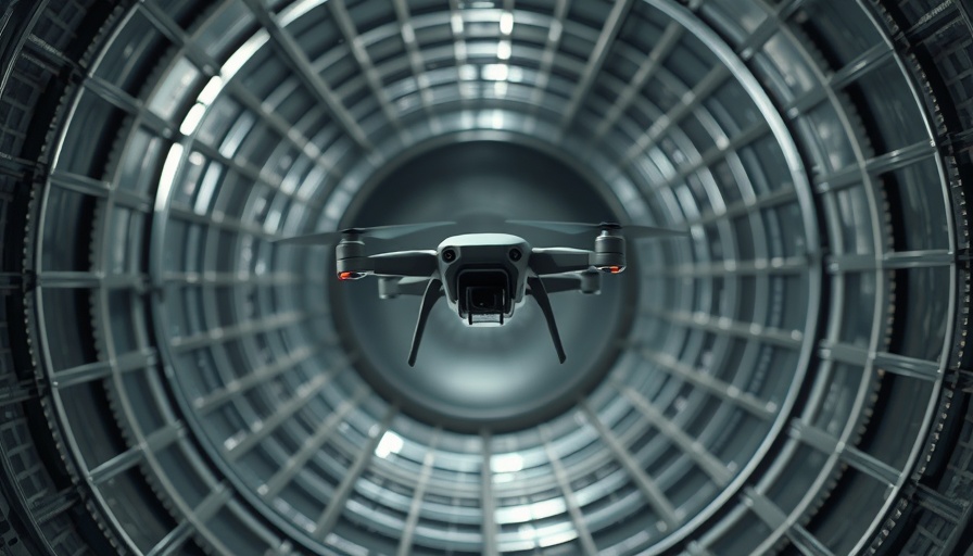
The nature of air ducts, with a diameter restricted to as little as 35 cm, prohibits human entry and, consequently, manual inspection. This limitation can lead to undetected issues that compromise air quality and system performance. Enter small quadcopter drones: their ability to maneuver both horizontally and vertically presents a potential game-changer. Yet, navigating these ducts isn't straightforward; the very presence of a drone creates airflow that can destabilize it, leading to turbulence that increases the risk of collision with duct walls.

Mapping Aerodynamic Patterns: A Scientific Approach to Drone Navigation

To combat this challenge, researchers from Inria, CNRS, and various French universities have embarked on groundbreaking studies into the airflow patterns within air ducts. Utilizing robotic arms equipped with force sensors, they constructed an aerodynamic map that reveals the complex dynamics at play. This pioneering work identifies perilous zones in circular ducts where drone instability could occur, thus guiding future drone engagements to avoid areas that pose the greatest risk.

Innovative Technology: Training Drones to Hover

Central to this research is the innovative approach of combining artificial intelligence with advanced sensor technologies. Using small laser systems and a neural network model trained on extensive motion capture data, the team has enabled drones to identify their positions accurately within the confined space. The result allows these drones to stabilize themselves in areas of reduced turbulence, significantly enhancing their safety during inspections.

Future Implications: Beyond Ducts

The implications of this research extend far beyond simple duct inspections. The next phase will encompass the development of a drone prototype capable of carrying sophisticated payloads, including cameras and thermal imaging devices. These technologies could redefine how buildings are monitored and could become integral in various sectors, from industrial inspections to public safety measures in emergency situations.

A Collaborative Effort Highlighting Research Potential

This project's success highlights the importance of collaborative research across institutions. The participation of esteemed organizations such as Inria, CNRS, and multiple universities underscores the shared commitment to pushing technological boundaries and fostering innovation. Such partnerships are not only critical for advancing drone technology but also for addressing broader societal needs.

As advancements in drone technology continue to unfold, it is clear that the ability to safely navigate and inspect confined spaces represents merely the beginning of a promising trajectory. The use of drones for inspecting air ducts could pave the way for further developments in infrastructure monitoring and disaster response.

Drone Applications

0 Views

0 Comments

Write A Comment

*
*
Related Posts All Posts
09.06.2025

Shooting a Drone: The Legal and Personal Fallout You Need to Know

Update Understanding the Legal Consequences of Shooting a Drone Many people are unaware of the severe implications that come with taking a shot at a drone. Recently, a man in a quiet neighborhood grabbed his firearm upon spotting what he thought was a suspicious drone hovering above his property. This unfortunate incident escalated quickly, resulting in his arrest and charges that included felonies and a hefty fine.We came across 'What REALLY Happens if You Shoot a Drone', which covers crucial aspects of drone interaction, and it raised some compelling points that we’re expanding on in this article. Under U.S. federal law, drones are classified as aircraft, and discharging a weapon at any aircraft—regardless of its size or function—is a serious crime. The Federal Aviation Administration (FAA) and federal statute, specifically 18 U.S.C. section 32, come down hard on those who endanger aircraft operations, making it imperative to understand the ramifications and safety protocols involved. Why the Increase in Drone Interactions? As drone technology becomes increasingly common—exemplified by Walmart's delivery drone initiative—instances of public discomfort and misunderstandings are on the rise. When individuals feel their privacy is violated, the knee-jerk reaction can often lead to regrettable decisions. With more drones flying over residential areas, education about drone rights and legal boundaries is more crucial than ever. What Actions Should You Take? If you find a drone hovering over your property, remain calm and do not resort to violence. Instead, consider the following steps: Document the drone's flight: Note the time, location, and any identifying details about the drone and its pilot. Contact local authorities: For immediate threats, utilize the local non-emergency line or your local police department. Know your rights: Familiarize yourself with local laws and regulations about drone flights. By taking these actions, you can address any concerns legally and without immediate confrontation. Best Practices for Drone Pilots For drone operators, making themselves known to the local community can reduce misunderstandings and potential disputes. This might include things like: Wearing a professional vest and using a clearly marked launch pad. Refraining from hovering over private property for long periods. Notifying residents in advance of planned flights in residential areas. Such measures create goodwill and may help prevent hostile interactions, ensuring that flying drones remains a safe and enjoyable activity. Common Misconceptions to Avoid Finally, it’s crucial to debunk some prevalent myths regarding drone ownership and the airspace above your property. Many individuals mistakenly believe: They own the airspace above their property—this is not true; airspace is managed by the FAA. Warning shots or lasers can be legally used to deter drones—introducing any weapon or beam into the airspace greatly increases liability and is illegal. Using a jammer would disrupt drone operation—jamming devices are illegal to use or possess in the U.S. Understanding these facts can help foster a more educated discourse on drone activity and enhance safety for all involved. The serious fallout from impulsively shooting at a drone holds valuable lessons for both the public and drone operators, stemming from incidents like the Walmart delivery drone strike. As drone technology continues to evolve, it becomes essential for communities to stay informed about regulations and best practices. Embracing this knowledge aids in minimizing future conflicts.

09.05.2025

Why the Drone-Powered 'Magic Box' is Revolutionizing Emergency Management

Update Introducing the Magic Box: Transforming Emergency Management In an age where every second counts, especially in emergency situations, the integration of technology can differentiate between life and death. Enter Project CLARKE, a drone-powered initiative from Texas A&M University, affectionately dubbed the "magic box". This innovative system employs artificial intelligence (AI) and machine learning to analyze images captured by drones, rendering a rapid assessment of disaster impact. Think Star Trek-inspired technology, now grounded in reality. How It Works: Within Minutes of a Crisis Imagine a hurricane wreaking havoc, leaving communities in disarray. The need for immediate information is palpable. CLARKE steps in to provide aerial imagery that, through a complex yet efficient AI algorithm, generates detailed maps (orthomosaics) depicting the level of damage sustained. In mere minutes, it can classify the extent of destruction to properties and infrastructures, enabling first responders to prioritize their efforts effectively. The Dual Phase Approach: Responding Effectively to Disasters Texas A&M’s approach is two-fold. The first phase is the immediate response, essential for situational awareness during the crucial first 72 hours following a disaster. Drones deployed in affected areas gather critical data that is relayed to CLARKE. The AI analyzes this data, presenting it in formats that meet the varied needs of different agencies: from spreadsheets to visual overlays indicating specific damage locations. The Real-World Impact of the Magic Box The proven effectiveness of the CLARKE system has been highlighted during the 2024 hurricane season when it was used to assess damages from Hurricanes Debby and Helene across multiple states. Emergency agencies reported significant improvements in their response strategies thanks to timely and accurate information generated by the system. Dr. Robin Murphy, who leads the project, shared insights on their collaboration with Florida UAS 1 and the Pennsylvania Emergency Management Agency, both of which utilized the technology to coordinate efficient responses in rural areas affected by flash floods and severe weather. The Future of Emergency Management Innovations As we enter the peak hurricane season of 2025, the prospects for Project CLARKE remain positive. With about 90 personnel trained across 53 emergency agencies, the reach and implementation of this technology are set to expand further. The potential for utilizing drone technology in various civic applications, from search and rescue to real-time damage assessment in other emergencies, will only enhance public safety and response efforts. This aligns with the broader trend of increasing reliance on drones for diverse applications post-disaster. Conclusions: A Game-Changer in Crisis Situations The advancements demonstrated by the magic box exemplify the marriage of technology with pragmatism in emergency management. As we continue to harness the capabilities of drones, AI, and machine learning, we can anticipate a future where disasters are managed with unprecedented efficiency and speed. To stay informed about advancements in drone technology and their potential applications in your field, subscribe for updates and insights delivered directly to your inbox.

09.05.2025

Mastering Drone Footage: The Importance of Preplanning Your Shoot

Update The Power of Preplanning in Drone Shoots In today's fast-paced tech landscape, the ability to effectively plan a drone shoot can be the difference between a stunning visual masterpiece and a frustrating session. This is particularly significant for drone hobbyists and industry professionals who are seeking to capture breathtaking footage or conduct detailed inspections. Preplanning offers not just a roadmap for the shoot, but also mitigates unforeseen challenges that can arise during filming.In 'Preplanning Shoot', the discussion dives into the essential strategies for planning drone operations, exploring key insights that sparked deeper analysis on our end. Why Preplanning Matters Without a solid plan, drone pilots risk wasting time and resources. Preplanning involves a thorough understanding of the shoot's objectives, site analysis, and weather conditions—all crucial components that can significantly influence the outcome. It ensures that operators know what angles and shots they want to capture, which can help avoid multiple take-offs and landings that can stress both the equipment and the pilot. Tools and Techniques for Success Utilizing flight planning apps is an excellent way to enhance the preplanning process. Many tools available today can provide maps, allow the pilot to set flight paths, and even assess obstacles. These applications can analyze airspace regulations to ensure the drone remains compliant, thereby fostering a safe operating environment. Additionally, favorable weather apps can help predict the best times to shoot from a visibility and wind resistance standpoint. The Emotional Connection to Drone Footage For enthusiasts, capturing drone footage is not just about visuals; it often embodies a passion for creativity and storytelling. When crew members and pilots share a vision through preplanning, they cultivate emotional investment in the project. This connection elevates the quality of the footage and serves to engage viewers on a deeper level. Future Trends in Drone Preplanning As drone technology continues to advance, we can expect that preplanning will evolve as well. Tools powered by artificial intelligence may emerge, allowing drone operators to predict optimal paths and adjusts automatically based on real-time data. Virtual reality could also enhance preplanning by providing immersive experiences, where operators visualize their plans before taking to the skies. Call to Action For anyone involved in drone operations, whether as a hobbyist or a professional, investing time in preplanning can immensely improve the quality of the shoot. Start implementing these strategies and tools today to take your drone footage to new heights!

Terms of Service

Privacy Policy

Core Modal Title

Sorry, no results found

You Might Find These Articles Interesting

T
Please Check Your Email
We Will Be Following Up Shortly
*
*
*