 Add Row
  Add
Add 


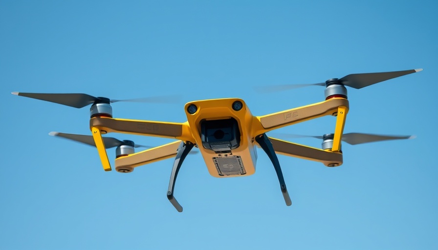
Revolutionizing Geospatial Intelligence: Meet the Q6V2 GEO UAV
In a groundbreaking development for drone technology, ideaForge Technology Limited has unveiled the Q6V2 GEO UAV at the PRAGYA 2025 event, showcasing its commitment to advancing geospatial intelligence. Tailored for a diverse array of applications, from urban planning to environmental monitoring, this UAV stands at the forefront of aerial surveying innovations.
Unmatched Versatility in Aerial Mapping
The Q6V2 GEO is engineered to tackle complex geospatial tasks regardless of location, offering an impressive flight time of over 50 minutes and the capability to handle multiple advanced payloads. Weighing in at under 7 kg, it combines lightweight design with robust performance, making it ideal for everything from glacier mapping in the Himalayas to urban infrastructure surveys. Its modular design allows users to seamlessly switch between high-resolution imaging, LiDAR, hyperspectral capture, and thermal detection.
Transforming Data into Actionable Insights
Integrating with ideaForge’s innovative geospatial tech stack, the Q6V2 GEO transforms raw data into precise, decision-ready information. This platform not only assists in urban planning by creating detailed 3D city models but also enhances agricultural productivity by enabling early detection of crop stress. Its applications extend to improved compliance reporting for the mining sector and risk assessments for utilities, showcasing how technology can drive efficiency and accuracy across diverse industries.
A Leap Forward for Disaster Management
The deployment of the Q6V2 GEO also marks a significant step forward in disaster management. This UAV enables rapid terrain assessments in challenging environments, critical for responding to emergencies in remote locations. Enhanced aerial intelligence can expedite rescue operations, demonstrating the UAV's potential to save lives.
Expert Insights on the Q6V2 GEO's Impact
According to Ankit Mehta, CEO of ideaForge, the introduction of the Q6V2 GEO signifies a paradigm shift in how organizations can utilize geospatial data: "The Q6V2 GEO gives our customers the power to operate in tough terrains and climates with unprecedented precision. Our aim is to empower decision-makers to see and act on their environment like never before.” This perspective highlights the UAV's role in pushing boundaries for what is achievable in various sectors, from governmental planning to environmental preservation.
Future Trends in Geospatial Technology
As drone technology continues to evolve, trends suggest an increasing integration of AI into UAV operations. The Q6V2 GEO’s advanced imaging capabilities and intelligent data processing could soon lead to smarter drones capable of predictive analytics and real-time decision support, further revolutionizing industries reliant on accurate geospatial data.
Overall, the launch of the Q6V2 GEO UAV establishes ideaForge as a leader in the drone industry, setting a new standard for versatility and performance. As businesses seek innovative solutions to enhance their workflows, this UAV presents an opportunity to embrace the future of geospatial intelligence.


Write A Comment