Add Row
Add Element
cropper
update
Drone Central Station
update
Add Element
  • Home
  • Categories
    • Drone Tech
    • Drone Applications
    • Drone Racing
    • Accessories
    • Real Estate
    • Military
    • Disaster
    • Drone Footage
    • Product Reviews
    • Business Profiles
August 04.2025
2 Minutes Read

Asylon's DroneDog Revolutionizes Security, Raises $26M for Future Innovations

Advanced robot patrolling nature with mountains; robotic security solutions.

Asylon's Pioneering Approach to Robotic Security

In an era dominated by advancements in artificial intelligence and robotics, Philadelphia-based Asylon is making waves in facility security with its innovative robotic offerings. The recent $26 million Series B funding round, led by Insight Partners, highlights a growing confidence in robotics as a security solution. Asylon's journey began with their focus on drones, particularly notable for a drone equipped with a robotic arm capable of changing its batteries autonomously.

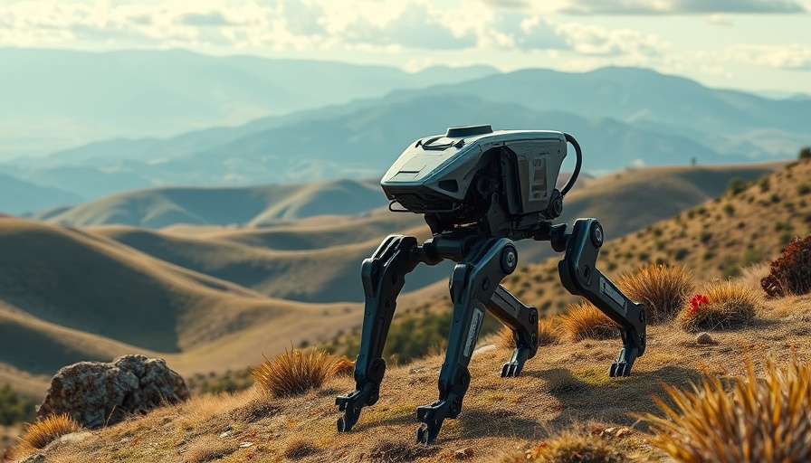
DroneDog: A Robotic Companion for Security

At the heart of Asylon's revolution is DroneDog, a modified version of the well-known Boston Dynamics robot dog, Spot. This robotic canine is not just an advanced gadget; it represents a tangible evolution in security technology. With the capacity to execute guard duties, the DroneDog integrates seamlessly with Asylon's command-and-control software known as Guardian. This allows for comprehensive security oversight, combining aerial drone patrols with ground surveillance.

The Rise in Demand for Security Solutions

Rising concerns over safety, particularly in high-profile cases such as the security breach leading to the tragic death of UnitedHealthcare CEO Brian Thompson, have spurred increased expenditure on enhanced security measures. Asylon’s robotic security as a service (RaaS) solution taps into this growing market. The company offers a compelling alternative to traditional security services, with comprehensive packages comparable to hiring a human bodyguard service, but with the added advantage of robotic efficiency.

The Shift Towards Automation in Security

Asylon's approach mirrors a broader trend in security, where automation is increasingly favored for efficiency and reliability. Autonomous robots like DroneDog are capable of patrolling hazardous environments, identifying threats, and responding to potential dangers without putting human lives at risk. Their ability to perform sophisticated tasks, such as detecting gas leaks or hazardous materials, showcases the practical applications of robotics in real-world scenarios.

Founders with a Vision

The origin story of Asylon is not just about technology, but also about an inspired journey through education and collaboration. The founders, Damon Henry, Adam Mohamed, and Brent McLaughlin, are MIT alumni who chose to combine their aerospace engineering backgrounds to innovate rather than dropping out to pursue typical tech startup paths. This dedication has allowed them to nurture their vision, leading to the creation of a multi-faceted security platform.

Conclusion: The Future of Robotic Security

Increasing interest in robotic solutions for security raises questions about the future of traditional security roles. Asylon's success with its series B funding not only reflects a promising outlook for drone and robotic technology in security but also marks a pivotal moment in the evolution of how we protect our spaces. With the tech world keenly observing these developments, it is evident that innovation in this space is just beginning.

Drone Applications

1 Views

0 Comments

Write A Comment

*
*
Related Posts All Posts
09.05.2025

Why the Drone-Powered 'Magic Box' is Revolutionizing Emergency Management

Update Introducing the Magic Box: Transforming Emergency Management In an age where every second counts, especially in emergency situations, the integration of technology can differentiate between life and death. Enter Project CLARKE, a drone-powered initiative from Texas A&M University, affectionately dubbed the "magic box". This innovative system employs artificial intelligence (AI) and machine learning to analyze images captured by drones, rendering a rapid assessment of disaster impact. Think Star Trek-inspired technology, now grounded in reality. How It Works: Within Minutes of a Crisis Imagine a hurricane wreaking havoc, leaving communities in disarray. The need for immediate information is palpable. CLARKE steps in to provide aerial imagery that, through a complex yet efficient AI algorithm, generates detailed maps (orthomosaics) depicting the level of damage sustained. In mere minutes, it can classify the extent of destruction to properties and infrastructures, enabling first responders to prioritize their efforts effectively. The Dual Phase Approach: Responding Effectively to Disasters Texas A&M’s approach is two-fold. The first phase is the immediate response, essential for situational awareness during the crucial first 72 hours following a disaster. Drones deployed in affected areas gather critical data that is relayed to CLARKE. The AI analyzes this data, presenting it in formats that meet the varied needs of different agencies: from spreadsheets to visual overlays indicating specific damage locations. The Real-World Impact of the Magic Box The proven effectiveness of the CLARKE system has been highlighted during the 2024 hurricane season when it was used to assess damages from Hurricanes Debby and Helene across multiple states. Emergency agencies reported significant improvements in their response strategies thanks to timely and accurate information generated by the system. Dr. Robin Murphy, who leads the project, shared insights on their collaboration with Florida UAS 1 and the Pennsylvania Emergency Management Agency, both of which utilized the technology to coordinate efficient responses in rural areas affected by flash floods and severe weather. The Future of Emergency Management Innovations As we enter the peak hurricane season of 2025, the prospects for Project CLARKE remain positive. With about 90 personnel trained across 53 emergency agencies, the reach and implementation of this technology are set to expand further. The potential for utilizing drone technology in various civic applications, from search and rescue to real-time damage assessment in other emergencies, will only enhance public safety and response efforts. This aligns with the broader trend of increasing reliance on drones for diverse applications post-disaster. Conclusions: A Game-Changer in Crisis Situations The advancements demonstrated by the magic box exemplify the marriage of technology with pragmatism in emergency management. As we continue to harness the capabilities of drones, AI, and machine learning, we can anticipate a future where disasters are managed with unprecedented efficiency and speed. To stay informed about advancements in drone technology and their potential applications in your field, subscribe for updates and insights delivered directly to your inbox.

09.05.2025

Mastering Drone Footage: The Importance of Preplanning Your Shoot

Update The Power of Preplanning in Drone Shoots In today's fast-paced tech landscape, the ability to effectively plan a drone shoot can be the difference between a stunning visual masterpiece and a frustrating session. This is particularly significant for drone hobbyists and industry professionals who are seeking to capture breathtaking footage or conduct detailed inspections. Preplanning offers not just a roadmap for the shoot, but also mitigates unforeseen challenges that can arise during filming.In 'Preplanning Shoot', the discussion dives into the essential strategies for planning drone operations, exploring key insights that sparked deeper analysis on our end. Why Preplanning Matters Without a solid plan, drone pilots risk wasting time and resources. Preplanning involves a thorough understanding of the shoot's objectives, site analysis, and weather conditions—all crucial components that can significantly influence the outcome. It ensures that operators know what angles and shots they want to capture, which can help avoid multiple take-offs and landings that can stress both the equipment and the pilot. Tools and Techniques for Success Utilizing flight planning apps is an excellent way to enhance the preplanning process. Many tools available today can provide maps, allow the pilot to set flight paths, and even assess obstacles. These applications can analyze airspace regulations to ensure the drone remains compliant, thereby fostering a safe operating environment. Additionally, favorable weather apps can help predict the best times to shoot from a visibility and wind resistance standpoint. The Emotional Connection to Drone Footage For enthusiasts, capturing drone footage is not just about visuals; it often embodies a passion for creativity and storytelling. When crew members and pilots share a vision through preplanning, they cultivate emotional investment in the project. This connection elevates the quality of the footage and serves to engage viewers on a deeper level. Future Trends in Drone Preplanning As drone technology continues to advance, we can expect that preplanning will evolve as well. Tools powered by artificial intelligence may emerge, allowing drone operators to predict optimal paths and adjusts automatically based on real-time data. Virtual reality could also enhance preplanning by providing immersive experiences, where operators visualize their plans before taking to the skies. Call to Action For anyone involved in drone operations, whether as a hobbyist or a professional, investing time in preplanning can immensely improve the quality of the shoot. Start implementing these strategies and tools today to take your drone footage to new heights!

09.05.2025

The Legality of Police Drone Operations: Navigating a Complex Issue

Update The Growing Conflict Over Drone Usage As drones become increasingly ubiquitous in both commercial and recreational spaces, legal and ethical dilemmas are arising about their use, particularly by law enforcement agencies. The question posed in the video titled Were these police flying drones illegally? highlights the tension between technological innovation and regulatory frameworks. Drones can greatly enhance police operations, offering surveillance capabilities that could lead to enhanced public safety; however, they also raise serious privacy concerns and require strict adherence to legal protocols.In Were these police flying drones illegally?, the discussion dives into the evolving legal landscape of drone usage by law enforcement, exploring key insights that sparked deeper analysis on our end. Understanding the Legal Framework In the United States, drone usage by law enforcement is subject to a patchwork of regulations that can vary significantly from state to state. The Federal Aviation Administration (FAA) governs most drone operations, but local laws can add additional restrictions. Often, drone deployments are limited to specific circumstances, such as search and rescue operations or monitoring large public events. However, the legality of aerial surveillance without a warrant remains a contested issue. Critics argue this could infringe on the Fourth Amendment rights against unreasonable searches, while proponents suggest that the surveillance capabilities can aid in crime reduction. The Tech Side: How Drones Are Changing Policing Drones, equipped with advanced cameras and sensors, can operate in ways traditional police procedures cannot. These unmanned vehicles can capture real-time evidence from above, making them invaluable during emergencies or routine patrols. As drone technology continues to advance, features such as thermal imaging and facial recognition software are becoming common. However, the community's concerns about privacy and potential misuse of such technology are equally rising. Hence, fostering discussions about the right balance between innovation in policing and public trust is critical. Implications on Community Relations The deployment of drones by police departments directly affects the relationship between law enforcement and the communities they serve. Transparency becomes key; communities must be informed about how drones are being used and what measures are in place to protect individual rights. Establishing clear guidelines around drone surveillance can not only improve public perception but also ensure that police forces are compliant with existing regulations. Future Predictions on Drone Regulations Looking forward, we can expect to see evolving regulations targeting police drone usage. As technology advances, legislative bodies are likely to follow suit, updating policies to better reflect modern capabilities and public opinion. This could involve stricter guidelines for transparency in drone operations and more robust training for law enforcement personnel regarding privacy rights and ethical considerations. As these systems grow, ongoing public dialogue will be crucial for shaping balanced and effective regulations. Conclusion and Community Engagement The question of whether police can fly drones legally raises broader discussions about technological progress and public trust. While drones offer innovative solutions to policing, they also bring significant responsibilities. Communities should advocate for clear regulations that ensure their rights are respected while allowing law enforcement the tools they need to maintain safety. As technology advances, it will be essential to engage in ongoing conversations about how to integrate these tools responsibly.

Terms of Service

Privacy Policy

Core Modal Title

Sorry, no results found

You Might Find These Articles Interesting

T
Please Check Your Email
We Will Be Following Up Shortly
*
*
*